Let's say you're looking for a type of place, rather than a specific place, to visit. You could be a skateboarder looking for an empty pool to ride in, an urban explorer looking for abandoned warehouses to explore... or you could be a bored internet user looking for satellite photos of shipwrecks off the coast of New York City just because it's cool.
A new website, Terrapattern, can do that for you.
Start by clicking anywhere on the map in one of four cities: New York, Detroit, Pittsburgh and San Francisco. Terrapattern will analyze a square measuring 256x256 pixels on the map, which is equivalent to 50x50 meters in real life, and find every other place in the city that looks like that square (from an aerial view, that is). Click a bus depot in New York, and boom, all of the other bus depots will appear with a photo and their location on the map.
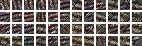
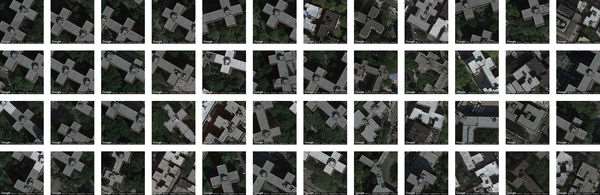
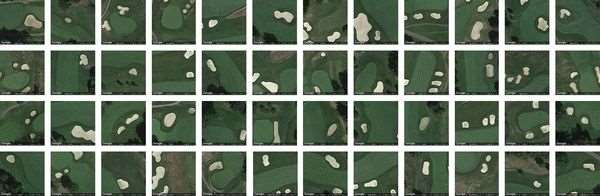
Terrapattern uses a Deep Convolutional Neural Network (DCNN) to perform the search -- which should be familiar if you remember Google's Deepdream artificial intelligence program, which turned ordinary photos into colorful blobs of dogs and eyes.
In this case, the researchers first needed to "train" the network by showing it hundreds of thousands of maps, which took about five days (thanks to the labeled satellite images from the crowdsourced OpenStreetMap project). The trained network could then look at a new picture, notice all of the curves, textures and other features, and use them to locate anything that matches. It's kind of like the way your brain knows a new mass of bread, meat and cheese is a cheeseburger because you've already seen thousands of other cheeseburgers.
"I wanted a way we could open this technology to everyone: citizen scientists, journalists and artists, or just everyday people who want to understand the world in a better way," said Golan Levin, Terrapattern project director, in an interview with Popular Science. He collaborated with developer David Newbury and artist Kyle McDonald, alongside Carnegie Mellon students Irene Alvarado, Aman Tiwari and Manzil Zaheer. Levin hopes people will see something like Terrapattern and offer feedback, and that we'll eventually see Terrapattern-like integration on platforms like Google Maps.
Searching four cities alone already requires 10GB of RAM; searching the whole US would take almost 2000 times that amount of memory, which would take much more sophisticated software. Until then, you can explore Detroit, New York, Pittsburgh or San Francisco with Terrapattern here.