Kevin Cheung
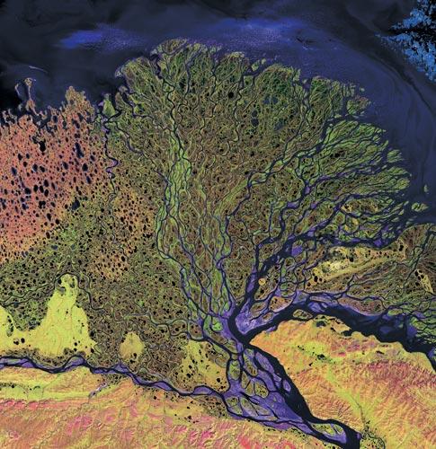
ANU researchers have helped to uncover the courses of some of the world’s oldest rivers and streams, buried for millions of years under the Simpson Desert in central Australia. The research project was able to peer beneath the desert sands to map the underlying landscape thanks to software that models how water moves across the surface of the continent.
The Digital Elevation Model (ANUDEM) software was developed at ANU by Professor Michael Hutchinson from the Fenner School of Environment and Society. Professor Hutchinson designed the original ANUDEM software and was instrumental in this latest research on ancient watercourses, working with John and Janet Stein from the Fenner School and Dr Robert Craddock from the Smithsonian Institution. The research is published in the latest edition of the Australian Journal of Earth Sciences.
Professor Hutchinson said the network of rivers and streams is now buried up to 35 metres below the surface of the Simpson Desert, making it impossible to detect by standard remote sensing methods. “The ancient drainage systems are thought to have originated in the wet climate of the late Cretaceous and Early Tertiary periods, around 50 million years ago. They are that old!” he said. “The landscape associated with these streams has been largely preserved due to long term tectonic stability and the persistence of arid conditions since the mid-Miocene around 15 million years ago. The age of the overriding dunes is thought to be around one million years.”
Professor Hutchinson said that although ANUDEM had allowed the research team to peer into the distant past, when central Australia was much wetter and greener than it is today, the software is also being used to model for the future. The latest version of the program marks the culmination of more than a decade of collaborative work with Geoscience Australia, to construct an elevation model with connected drainage structure covering the whole of Australia, with a grid spacing of nine seconds in longitude and latitude, or roughly every 250 metres.
Popular Science has been a leading source of science, technology and gadget news since 1872. With up-to-the minute latest space news, insightful commentary on the new innovations and concept cars ...if it's new or future technology you'll find it at popsci.com.au.
WW Media - Popular Science © 2010
Technology - DIY - Videos